Health & Fitness
Impacts Map for 11/27/13 Storm- Final Forecast
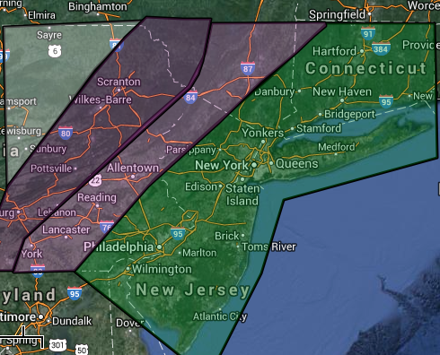
The following map covers the impacts of the storm for Tuesday afternoon through Wednesday evening. The coastal storm will start to impact the Philadelphia and New York City metropolitan areas by Tuesday afternoon after 2 PM and is expected to exit the Philadelphia and New York City metropolitan areas by Wednesday at 10 PM with lingering snow showers.
GREEN: These locations can expect mostly rain as the low pressure system will move right over these locations. The rain will start as showers on Tuesday afternoon and will become moderate to heavy late Tuesday night through Wednesday morning. The rain will change over to snow showers with accumulations of less than an inch. Rainfall amounts of 1 to 3 inches with locally higher amounts up to 4 inches possible.
Find out what's happening in Freeholdwith free, real-time updates from Patch.
PINK: A mix of snow, sleet, and rain will change over to all rain by late Tuesday night and then change back to snow on Wednesday morning. Rainfall amounts of 1 to 3 inches can be expected. Ice accumulations of up to 0.10" will be possible. Snow accumulate of up to 2" will be possible on Wednesday morning, mostly on cold surfaces.
Find out what's happening in Freeholdwith free, real-time updates from Patch.
PURPLE: A mix of snow, sleet, and rain will change over to rain on Tuesday evening before changing back over to snow on early Wednesday morning. Rainfall amounts of 1 to 2 inches can be expected. Ice accumulations up to 0.10" will be possible. Snow accumulations of 2 to 4 inches can be expected, especially on cold, grassy surfaces.
WHITE: A mix of snow, sleet, and rain will change over to all snow by Tuesday night. The precipitation will end by Wednesday morning with accumulations of 3 to 6 inches.
The storm will exit quickly on Wednesday however snow showers will be a lingering threat into Thanksgiving morning. Temperatures will peak in the mid to upper 50's along the coast, upper 40's to lower 50's just northwest of the New York City and Philadelphia metropolitan areas, and lower to mid 40's over the northern interior by early Wednesday morning. Winds will veer from the southeast to the northwest at 10 to 20 mph, increasing to 15 to 30 mph from the northwest by Thanksgiving morning.
Should the track of this low pressure system shift west or east by 30 miles or more, significant changes to this forecast will have to be made. At this time, there are no indications of such a shift.


