Health & Fitness
Major changes on the way as Arctic front approaches
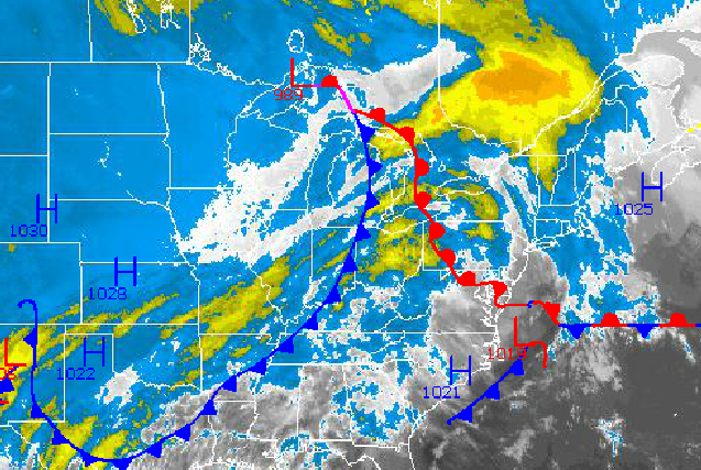
As an Arctic cold front approaches the East coast over the next two days, warm air will surge into the Philadelphia and New York City metropolitan areas through tomorrow morning. With the warm air, areas of fog and widely scattered showers will be a threat along with well above normal temperatures. However, by tomorrow night temperatures will be crashing through the 30's with periods of rain changing over to snow.
Today through tomorrow morning, a warm front will drive northward with broke to overcast cloud cover and isolated showers a threat. Areas of fog will be a threat through 11 AM this morning and will be a threat early tomorrow morning as well with visibility below 2 miles in some locations. Winds will be from the southwest at 5 to 15 mph, increasing to 10 to 20 mph by tomorrow morning. Temperatures this afternoon will rise into the mid to upper 50's over the interior and upper 50's to lower 60's along the coast and in urban areas.
The Arctic cold front will drive through the region tomorrow with periods of rain expected. High temperatures will be in the morning hours in the lower to mid 50's. Temperatures will gradually slow through the 40's and into the 30's by tomorrow evening.
Find out what's happening in Freeholdwith free, real-time updates from Patch.
As the cold air invades, the rain will change over to snow tomorrow night into Saturday morning. Most locations will only have a few passing snow showers on Saturday morning, however some minor to moderate snowfall accumulation can be expected. The snow accumulation map for Saturday can be found here. The snow will end rapid on Saturday morning with clearing skies by the afternoon. Temperatures will range from the lower to mid 30's for lows and mid to upper 30's for highs.
An Arctic high pressure system will take hold on Saturday night into Sunday with clear skies in the morning followed by increasing clouds in the afternoon. Winds will be from the northwest and north at 5 to 15 mph. Temperatures on Sunday will range from the upper 10's to lower 20's over the interior and mid to upper 20's along the coast for lows and lower to mid 30's over the interior and mid to upper 30's along the coast.
Find out what's happening in Freeholdwith free, real-time updates from Patch.
An area of low pressure will drive northward on Sunday night into Monday with an advancing warm front moving through the region. Light snow will start throughout the Philadelphia and New York City metropolitan areas on Sunday evening. The snow will change over to rain quickly along the coast with minor snowfall accumulations expected. However, further inland the snow will change over to sleet and freezing rain with significant ice accumulations possible. Details on the preliminary storm impacts can be found here.
All locations will gradually change over to rain on Monday morning. Another Arctic cold front will follow on Monday afternoon with scattered showers expected. Arctic high pressure will be in control Tuesday and Wednesday with scattered cloud cover and cold conditions. Temperatures on Monday will range from the upper 30's to lower 40's over the interior and mid 40's to lower 50's along the coast for highs. On Tuesday, temperatures will range from the lower to mid 30's for lows and upper 30's to lower 40's for highs. On Wednesday, temperatures will range from the mid 10's to lower 20's for lows and lower to mid 30's for highs.


